

From the great wings of albatross soaring through salty gales, to penguins and seals navigating the currents alongside myriad microscopic plankton, the Southern Ocean is full of life.
Circling Antarctica, it’s the planet's wildest and most remote ocean, with monster waves that scare even the most fearless of sailors. This inaccessibility means it’s one of the most under-observed regions on the planet.
However, this rugged landscape is key to our survival, and perhaps one of the most important for us to understand in the face of global climate change.
To a large extent, the Southern Ocean controls the uptake of human-generated heat and carbon into the ocean, and helps keep our planet liveable.
It influences ocean circulation and climate on a global scale, and controls the rate of melt of the Antarctic ice sheet – the single-greatest uncertainty in projecting future sea level rise.
FOCUS at sea
Monitoring and observing such an extreme environment requires collaboration between nations and disciplines.
This is exactly what we see in the current FOCUS voyage, co-led by CSIRO and the Australian Antarctic Program Partnership.
On 15 November, the 54-strong interdisciplinary team set sail from Hobart aboard CSIRO research vessel RV Investigator.
The ship headed south straight for the energetic heart of the Southern Ocean – the Antarctic Circumpolar Current (ACC) – that swirls clockwise around Antarctica and helps keep it cool.
The aim of the FOCUS voyage – standing for Fine-scale Observations of the (Antarctic Circumpolar) Current Under SWOT – is to understand why more heat is seeping through the current towards the icy continent.
Voyage co-chief scientist Associate Professor Helen Phillips, from the Australian Antarctic Program Partnership at the University of Tasmania, says:
“Taking our voyage to this hotspot will tell us a lot about what’s controlling heat movement across the Southern Ocean towards Antarctica, and how that might change in the future.”
But building a picture of what's going on in the Southern Ocean is no easy feat. And this voyage is relying on measurements from both space and the ocean.
Taking the ocean’s pulse from above
Orbiting more than 890km above us, the SWOT satellite co-designed by NASA and French space agency CNES is helping to measure the height of the ocean.
It has 10 times better resolution than preceding technologies, and can detect differences in sea surface height down to just a few centimetres.
This means scientists can see smaller-scale circulation features where most of the ocean’s heat and carbon is mixed and transported.
Co-leader of the oceanography project with the Australian Antarctic Program Partnership, Dr Benoit Legresy, from CSIRO, said:
“This new capability to map the ocean will boost our capacity to monitor and forecast the ocean very much like we forecast the weather.”
Oceanic toolbox
Meanwhile, the ocean-bound team is relying on the scientific capabilities of RV Investigator to explore below the waves.
Let’s take a look at the toolbox helping scientists “taste” the properties of the ocean within their 100km by 200km survey area.
The deep-divers
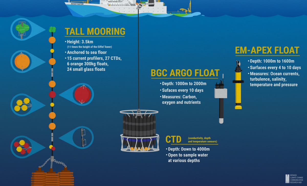
At the centre of the survey area sits a 3.5km-tall mooring, anchored to the seafloor.
We can think of it like the middle of a solar system – a central point used to connect what’s happening below the surface of the ocean with what the satellite observes above.
It’s a vertical string of more than 50 oceanographic instruments supported by gigantic floats that help it stay upright.
As Dr Legresy notes: “It's an awesome installation of science infrastructure 11 times the height of the Eiffel Tower.”
Next comes the CTDs (conductivity, depth and temperature sensors), which are like deep-sea divers, scouting the depths of the ocean around the clock.
These instruments, sitting within a barrel-like frame called a rosette, are lowered to the bottom of the ocean – often about 4000m deep.
They collect samples of water at various depths and give us a profile of carbon dioxide concentration, what’s living there, how cold and salty it is, and how quickly currents are moving.
Over the course of this particular voyage, the rosette will be lowered more than 100 times, giving scientists a wealth of data to examine back on land.
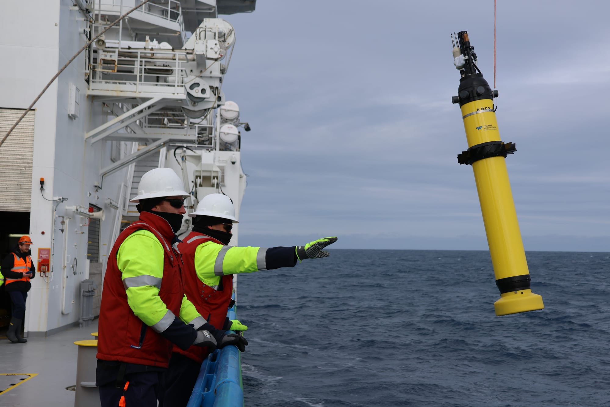
In this deep-sea group, we also have two types of floats, both of which just go with the flow.
The BGC Argo float moves with the currents at a “parking depth” of 1000m, then sinks to 2000m before surfacing every 10 days.
These floats measure carbon, oxygen and nutrients, telling us about changes to ecosystems and the ocean’s uptake of carbon dioxide.
In contrast, its “sister” float, the EM-APEX float, is enhanced with sensors to measure ocean currents and turbulence.
Both of these will survey our oceans and transmit data for many years after being deployed.
Middle managers
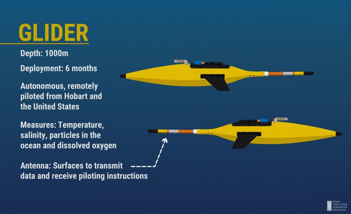
Gliders are like the frequent flyers of our oceans, spending long stints away from home.
Once deployed, they remain in the ocean for six months, remotely piloted from Hobart and the US.
Along the way, they zig-zag across Argo float pathways to depths of up to 1000m, and surface every so often to transmit data and receive piloting instructions from shore.
“On this mission they’ll help us track the floats we deployed and provide information about the water column, unobtainable from the satellite above,” says Luna Bai, a Caltech graduate student.
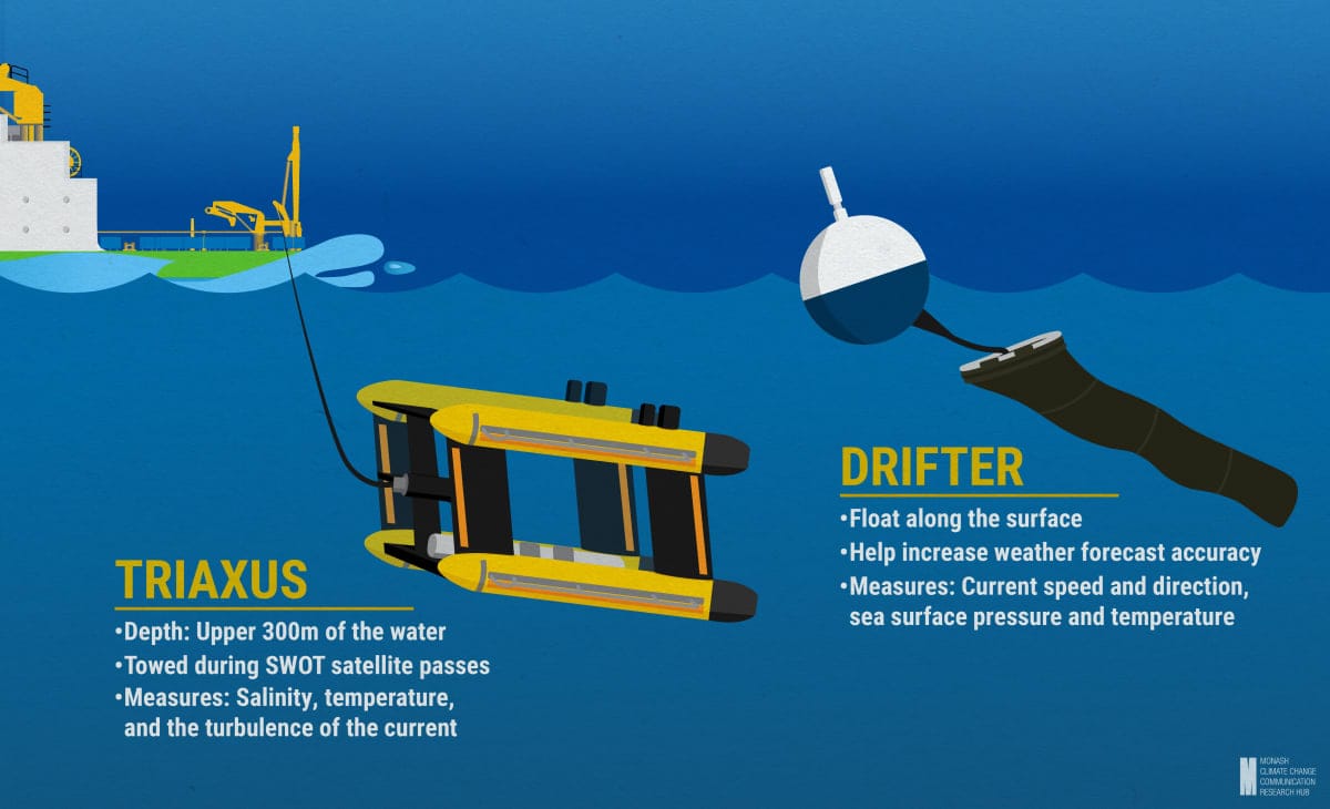
Surface swimmers
Moving closer to the surface, we find two final pieces of equipment that are instrumental to satellite data validation and weather forecasting.
During satellite passes over the survey area, the box-shaped Triaxus comes out to play.
This instrument is towed behind the ship, and undulates up and down through the upper 300m of the water.
Along its journey it captures information about salinity, temperature, dissolved oxygen, nitrate, chlorophyll, particle concentration, and the turbulence of the current to help validate and complement the satellite data.
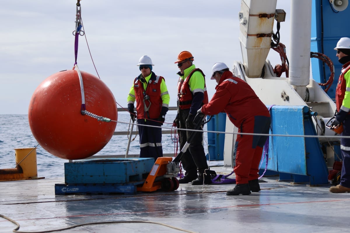
In contrast, drifters bob along the surface, hitching rides with whirling eddies.
The FOCUS voyage has released more than 10 of these so far, and we can see them spiralling around the tall mooring and across the satellite’s path.
As they move further afield, they’ll give us powerful information about current speed and direction, as well as sea surface pressure and temperature.
Their data is also used to increase the accuracy of weather forecasts around the world, and to show ships where currents are that will give them a boost.
Reeling it in
The Southern Ocean is a unique “natural laboratory” for vital scientific research, impossible to achieve anywhere else on the planet.
This state-of-the-art toolkit will help take us from slow-motion, low-resolution oceanography to real-time high-definition.
And, the essential data gathered during the voyage will help us understand why our planet is changing, and underpin improved projections of future climate and sea level rise.
Ultimately, this will help scientists provide governments and communities with the information they need to adapt to a rapidly-changing world.
This research is supported by a grant of sea time on RV Investigator from the CSIRO Marine National Facility, which is supported by the Australian government’s National Collaborative Research Infrastructure Strategy (NCRIS).


