

Key points:
- A new tool offers an unprecedented ability to map the extent and severity of the fires.
- Working with satellite data, the new tool can observe the overall progression of a fire front.
- Unlike tools used previously, this one is capable of penetrating through smoke.
- The tool can be used to track regrowth and recovery of trees and plants following a fire.
To comprehensively manage the risks of more prolonged and extreme bushfire seasons under climate change, we need a properly-funded and coordinated multi-agency response, with a data science approach at its core.
While the Bushfire and Natural Hazards CRC has delivered some tangible outputs, a dedicated team within a new institute specifically aimed at managing the pre-fire risk and post-fire recovery is recommended, and would strongly cement Australia’s position as the international leader in the field.
Fortunately, researchers, government and land management agencies are already working together to produce innovative assessment tools that can help manage the risk, and to better inform the strategic deployment of already-stretched operational resources.
Data-driven fire response
Our team of Monash University researchers, including partners from CSIRO/Data61 and the Australian National University, in exchange with the Country Fire Authority (CFA) and Rural Fire Service (RFS), has developed a tool that can produce maps of forest conditions at a resolution of 25 metres, high enough to identify anomalies caused to trees by a range of factors, including fire damage, drought or disease.
The tool, called the Vegetation Structure Perpendicular Index (VSPI), uses data taken from the Landsat and Sentinel-2 satellites, operated by NASA and the European Space Agency, and made freely available by Geoscience Australia. It applies algorithms to the data to produce vegetation condition maps at a higher spatial and temporal resolution than previously available to operational modelling tools.
Our tool offers an unprecedented ability to map the extent and severity of the fires.
Through applying the VSPI algorithm to satellite data, we can produce maps for any location, including the recent fire-affected areas west of Sydney.
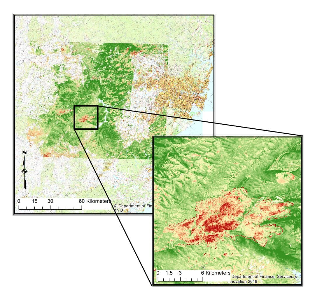
In these maps, the green areas indicate normal conditions, whereas the yellow, orange and red areas indicate the escalating severity of damage. By displaying an integrated picture of moisture content, vegetation structure and cellulose material levels, our tool offers an unprecedented ability to map the extent and severity of the fires.
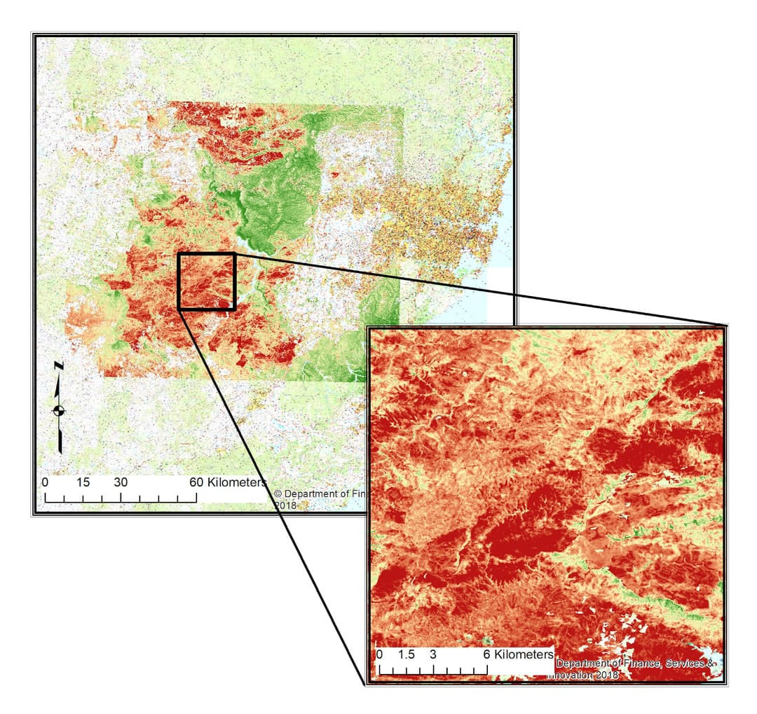
The maps show that the fires do not seem to be burning with the same intensity everywhere, which may be due to topography, moisture content, or other factors.
These maps are a step up from the industry-standard variants of the normalised burn ratio (NBR), as they use data obtained purely from bands in the short-wave infrared spectrum, a method capable of penetrating through smoke to produce near-real-time maps. In comparison, the NBR also relies on the near-infrared band, which requires smoke and cloud-free conditions to produce a useful image.
Our third map is a binary version of the previous maps, showing the cumulative spread of the fires between 1 December and 31 December, 2019. The map provides a time-integrated view of the fire extent (displayed in black), but also indicates the advancing fire front as observed during a satellite overpass (displayed in yellow).
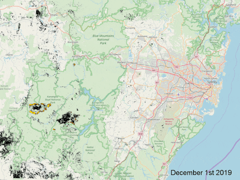
With the capacity to observe the overall progression of the fire front, critical fire-spread models can be validated, and we can recommend and support other predictive and preventative tasks during active fires.
Since our tool is essentially a vegetation condition index, we can also use it to track regrowth and recovery of trees and plants following a fire, and offer operational agencies new capabilities in deciding where best to plan and undertake preventative burn-offs in areas of highest need, more efficiently and effectively than before.
Using satellite data obtained every 12 days or better, we can also use the tool to build more accurate fire-risk and fire-spread models over time, a critical component of offering effective bushfire risk management.
Preparing for the future
Given the predictions of more prolonged and extreme bushfire risk under climate change, we must focus on making better use of the vast amount of satellite data we have available, for free, and use tools such as the VSPI to embed a more coordinated and concerted data science approach to bushfire management.
But in order to efficiently harness all the available data and effect the most accurate risk management and emergency response strategies, we need data scientists, environmental climate scientists and engineers to collaborate with the operational agencies, with serious funding behind them.
Whatever form it takes, a new national bushfire institute should focus on the direct integration of scientific capabilities and operational requirements, informed by the vast data resources available.
Staff should be seconded from across the network of universities and government agencies, with input and support from industry, to truly work together. Links into space agencies, the Intergovernmental Panel on Climate Change, and the World Meteorological Organisation would also ensure a globally-integrated outlook into the future, and as a whole could better inform management practices in other regions of high risk, such as California and Portugal.
The creation of a national bushfire institute will reduce siloing and competition for limited funding, and ensure a coordinated effort in producing targeted and collaborative research for the public good, and help our fire agencies to further improve their operational decision processes.
As a result, we’ll have safer communities that will be better-prepared to face bushfire risks into the future.


